|
|
| |
Carbon Baseline - Expedition in the Greater Mahale Ecosystem - 2017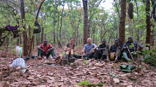 | | Carbon Tanzania is a social enterprise with an innovative approach to habitat conservation based on selling carbon offsets that result from keeping carbon locked up in forest ecosystems. These forests are owned by indigenous communities who earn an income from the sale of these offsets, funds that are then used for community development needs. Global climate change is real and has already had observable effects on the environment. Glaciers have shrunk, ice on rivers and lakes is breaking up earlier, plant and animal ranges have shifted and trees are flowering sooner. Carbon dioxide (CO2) is an important heat-trapping (greenhouse) gas, which is released through human activities such as deforestation and burning fossil fuels, as well as natural processes such as respiration and volcanic eruptions. The forests retain large carbon stocks, and when they are cut down for charcoal production, agriculture or wood extraction, carbon dioxide is released, thereby contributing to global climate change.By preventing deforestation, that globally contributes to almost a third of all greenhouse gas emissions, communities can earn carbon credits which can be sold on the global voluntary carbon market, thereby providing revenue which is used to directly in forest conservation as well as pay for sustainable projects and basic services provision within the villages. To determine how much carbon is stored in these forests you have to physically walk to randomly assigned sample plots and carry out measurements based on internationally recognised survey methodologies. |
Photogallery
Ruvuma Expedition: mammal and bird survey along the Ruvuma River 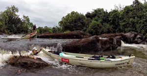 | | The Ruvuma River forms the border between Tanzania and Mozambique, an area of high biodiversity linking the Niassa Game Reserve with the southern Selous Game Reserve. The Selous - Niassa Miombo woodland ecosystem as a whole is the largest trans-boundary natural dry forest ecosystem in Africa covering 150,000 km2 and extends across southern Tanzania into neighbouring Mozambique. The wide variety of wildlife habitats - forests, wooded grasslands, open savannahs, granite inselbergs, seasonal and permanent wetlands and rivers - account for globally significant biodiversity. The core conservation areas for its continued existence are:
the Selous Game Reserve (47.000 km2) of Tanzania, UNESCO World Heritage-Site
the Niassa Game Reserve (42.400 km2) of Mozambique
The Selous Niassa Wildlife Corridor provides a significant biological link between the two reserves and consequently for the Miombo woodland eco-system, thus conserving one of the largest elephant ranges in the world containing also approximately 13% of the worlds remaining wild dog population.
Paucity of data in this area is due to the lack of roads making a river bound expedition the only viable option. The team has canoed for 250km along the river and collected mammal and bird data. |
 Expedition Report (5557 Kb) Expedition Report (5557 Kb)
Filling the knowledge gaps: an ecological expedition to central Tanzania  | | For the past half-century or more, conservation goals have focused on saving endangered species and establishing protected areas, which now cover approximately 10% of the earths land surface. Whilst this protected area network creates a link of genetic variability, many species, especially large mammals continue to decline. This decline in some areas is not surprising, as the protected areas include only a small portion of the annual migratory range of large herbivores, in other words, only part of the ecosystem in which they require to survive. In 2009, the billionth African was born, and with this expanding human population we see an increase in conflict over land between wildlife and people.
In order to sustain biodiversity and to efficiently manage ecosystems, it is essential to monitor wildlife outside of protected areas. Fostering local conservation efforts, encouraging data collection and monitoring of unprotected areas is crucial to guard vital landscapes, such as migratory corridors. The quantification and distribution of species outside protected areas and the determination of the factors governing population trends are therefore necessary for the implementation of successful conservation policies within Tanzania. The Tanzanian bird atlas and Tanzanian mammal atlas have management objectives at the core of their philosophy, providing free data to land mangers and government in order to better enable policy makers to include biodiversity at every level of planning. |
Report (5998 Kb)
Maputo Special Reserve,Machangulo and Marine Periphery - wildlife and human impact survey | | The Maputo Special Reserve (MSR), Machangulo Penninsula, and surrounding waters of Maputo Bay and the Indian Ocean represent one of Southern Africas most biodiverse and scenic conservation land- and seascapes, and a place of extraordinary potential to contribute to local and national development goals through ecotourism. The Wildlife Conservation Society, an international conservation NGO, was asked to contribute to this effort by the Machangulo Group of landowners with the cooperation of Peace Parks Foundation (a southern African conservation NGO) and the Government of
Mozambique. An integrated ecological and human impact survey of the terrestrial and near shore marine environments of the MSR and Machangulo, including Maputo Bay, was conducted in March, 2009.
The Groups aim was to assess the areas global conservation significance, clarify the areas conservation status, and identify potential conservation challenges. Ten experts from various conservation fields carried out the assessment during a three-week period. |
MACHANGULO LOCAL COMMUNITY PROJECT | | The Machangulo Peninsula is situated in the southern most part of Mozambique adjacent to Inhaca and Portuguese Island in the Bay of Maputo. With a land area of about 10.000ha it includes about 20Km of pristine coastline, an incredible lake system and a vast territory of indigenous bush flanked by the calmness of the bay on the Western side and the Indian Ocean on the East. The peninsula has markedly different West and East shores. On the West there are muddy tidal plains partially covered by mangrove forest whereas the East is much steeper with high dunes covered by woodland and sandy beaches. In the South the peninsula is linked to the continent through the Maputo Special Reserve (MSR), a key area for conservation. Machangulo has a unique location, found within an ecosystem which is globally important for both marine and terrestrial biodiversity conservation, as well as local and national economic development through subsistence activities and tourism.
In 2008 the Machangulo S.A. was given the concession of the area and is currently building holiday homes and a hotel. This major project, currently underway on the peninsula, not only focuses on the development aspects but has two other primary objectives:
1. Improvements for the local community in terms of health, education and employment
2. Conservation of the environment in the adjoining shoreline and marine territory as well as the Maputo Special Reserve
This preliminary study aims to identify the major human settlements and main public utility structures, such as waterholes, clinics and schools in the peninsula and to recognize the local communitys primary needs. It will therefore provide baseline data for undertaking immediate action. |
Photogallery
SNOW LEOPARD PROJECT | | In the world, the total effective population size of the snow leopard Uncia uncia (SCHREBER, 1775) is estimated at 2500-5000 mature breeding individuals, with a declining trend due to habitat and prey base loss and persecution, and no subpopulation containing more than 250 mature breeding individuals (classified as endangered EN C2ai , IUCB/SSC Cat Specialist Group 2002).
In the 1960s, the endangered snow leopard Uncia uncia was locally extirpated in what is now Sagarmatha (Mt. Everest) National Park. In 1987, Ahlborn and Jackson (1987) reported some signs, probably made by transient cats from Tibet, in the Gokyo area of the Park. The Park was established in 1976 and, after almost three decades of effective protection measures, the virtual cessation of hunting as well as the recovery of the endangered Himalayan tahr and musk deer, snow leopards have recently made a comeback to the worlds highest national park. This research has the aim to estimate and monitor the snow leopard population in Sagarmatha National Park. |
Report November 2006 (28 Kb)Photogallery
TARANGIRE LION PROJECT | | The lion, the largest predator in Africa, represents one of the key animal species and is a major attraction.
Over the past century lion populations have been declining all over Africa and have disappeared throughout central Asia, ( except for those living in the Gir Forest National Park ), and the Middle East. In Africa they are now mainly confined to National Parks, Game reserves and their surrounding areas. The main cause of this decline is the loss of wildlife habitat due to the expansion of agriculture and livestock, however, in some areas, unsustainable hunting and poaching are the main limiting factors. Human expansion, in general, threatens the survival of the main African predator by reducing its numbers and by isolating the lion populations and therefore increasing the risk of in-breeding.
Since 1998 the Tarangire Lion Project has been collecting data in order to examine the population structure and dynamics of the lions, within the Park. This helps to determine what effect trophy hunting, as well as interaction with local communities in surrounding areas, has on the lion population´s demographics. This research also directly serves in our attempt to extrapolate a population estimate for the future. |
Report - May 2005 (289 Kb) Report - dry season 2003 (272 Kb) Report 2002-2003 (1497 Kb) Map - Home Range dry season, collared prides (128 Kb) Map - Sightings wet and dry season, collared prides (113 Kb) Map - Lion-Elephant interaction (119 Kb)Photogallery
|
| |
|